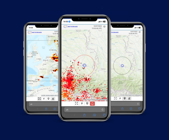
METEORAGE live
Thunderstorm episode in Spain
At the end of October 2024, stationary thunderstorms and intense electrical activity aggravated flooding in the Valencia region. Read our analysis to understand this extreme weather event.
The Valencia region in Spain was hit by an exceptionally intense rainfall event in late October and early November 2024, following a red alert level warning issued by AEMET, Spain’s state meteorological agency.
A meteorological phenomenon known as a ‘cold drop’ caused record rainfall, leading to devastating floods.
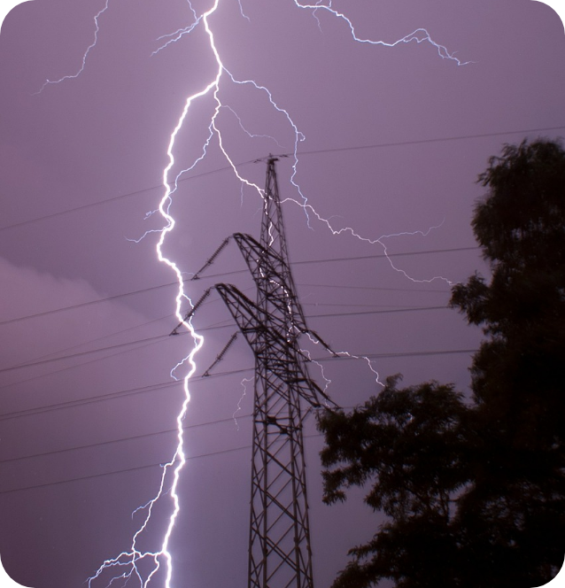
Stationary thunderstorms and intense electrical activity exacerbated the situation.
Climate change, with higher temperatures of the Mediterranean and a more humid atmosphere, contributed to the intensity of this event.
Discover our full analysis.
Analysis
Thunderstorm episode in Spain
from 25 October to 4 November 2024
By Joris Royet, Weather Project Manager, METEORAGE.
Weather conditions
Although this was a major episode, the atmospheric condition was fairly typical for this area in the autumn. Once autumn begins, air masses collide when cold air descending toward lower latitudes meets the opposing warm air in those latitudes.
In late October 2024, very cold air moved all the way down to Morocco, with temperatures reaching -25°C at around 5,000 meters altitude. This cold air met the much warmer air from the Mediterranean, which was also laden with moisture.
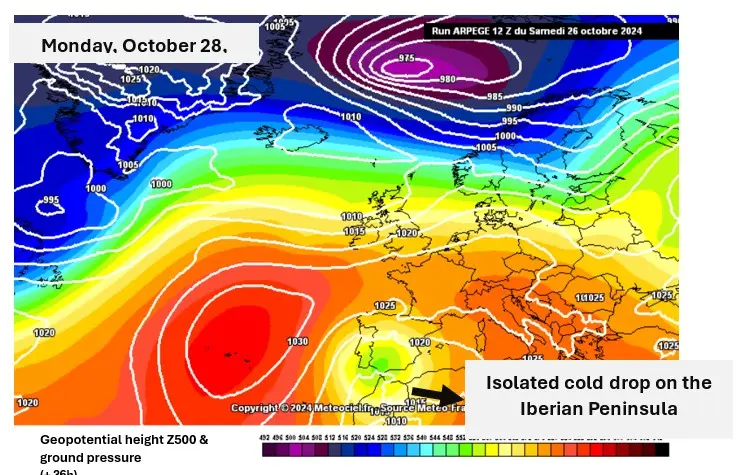
The episode began with a “thalweg” (low-pressure trough) approaching Western Europe at the end of October (Figure 1 showing the geopotential at 500 hPa, Arpège model), bringing considerable instability to Western Europe and France, with significant electrical activity over the southern half of the country. There was even talk of a major Mediterranean episode around October 25 (Figure 2).
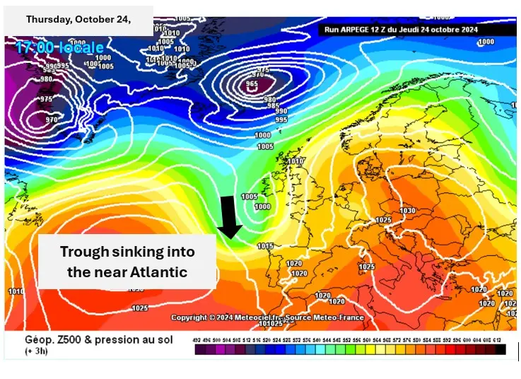
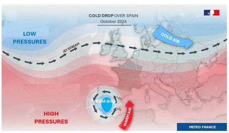
A few days later, this low-pressure trough broke away from the jet stream (the main west-to-east air current at higher latitudes) and moved farther down, reaching the Iberian Peninsula on October 27. As it had detached from the main stream, it was no longer a trough but a cold drop or cut-off low (COL). This cold drop was then trapped in the middle of high-pressure areas (anticyclones) over much of Europe (Figure 3 showing the geopotential at 500 hPa, Arpège model).
This cold drop, known as “DANA” for “Depresión Aislada en Niveles Altos” in Spanish, was blocked for several days toward the Strait of Gibraltar. It generated extreme downpours, causing widespread flooding in the eastern part of Spain located in front of this cold drop (Figure 4).
Chronology of events
This trough, which later turned into a cold drop, left significant damage in its wake, and not just in Spain. A look back at the chronology of events.
OCTOBER
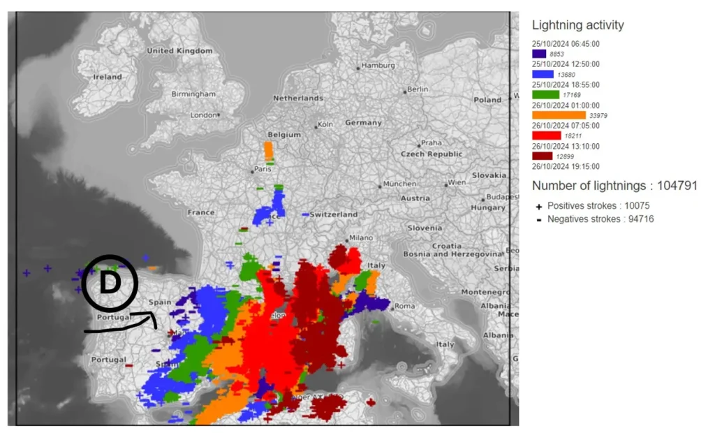
The long-wavelength trough was responsible for widespread storm damage over much of Spain and the Mediterranean Sea. These are known as pre-frontal thunderstorms, as they form ahead of the cold front. They moved from west to east, reaching Sicily and Southeast France during the day on October 26 (Figure 5).
OCTOBER
In addition to the wave of storms between Spain and Sicily, intense rainfall affected southeastern France in a southerly flow. The direction of the flow created a blockage over the Cévennes, hence the term Cévenol episode. Rainfall exceeded 300 mm locally in Var (83). Moreover, this Cevenol episode occurred a week after a major episode in the same area.
OCTOBER
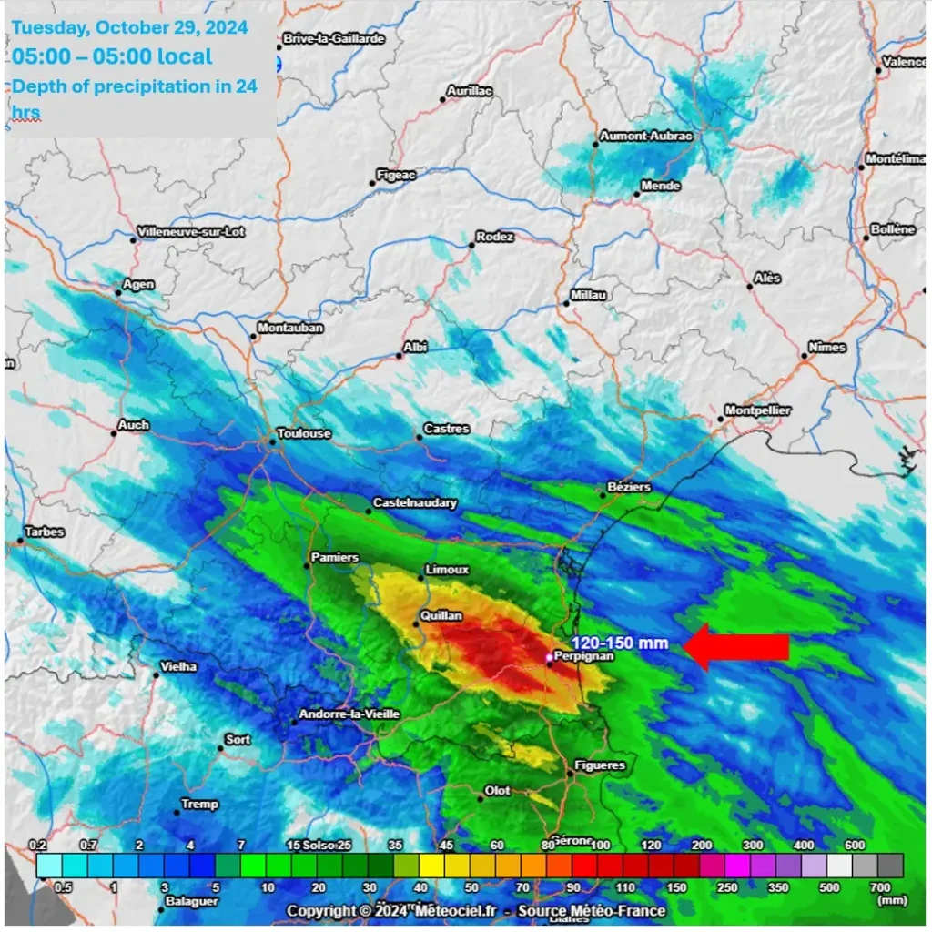
The Cévennes were not the only region affected during this episode, with Pyrénées Orientales “finally” receiving some decent rainfall. Over 130 mm of rain was recorded in Perpignan on the night of October 28-29 (Figure 6). This city received half of the total rainfall of 2023 in just 24 hours. The whole département received rain, which is the only good outcome of this episode.
It is worth remembering that Pyrénées Orientales had been experiencing chronic drought for almost 3 years. This rain is therefore very welcome in the département.
OCTOBER
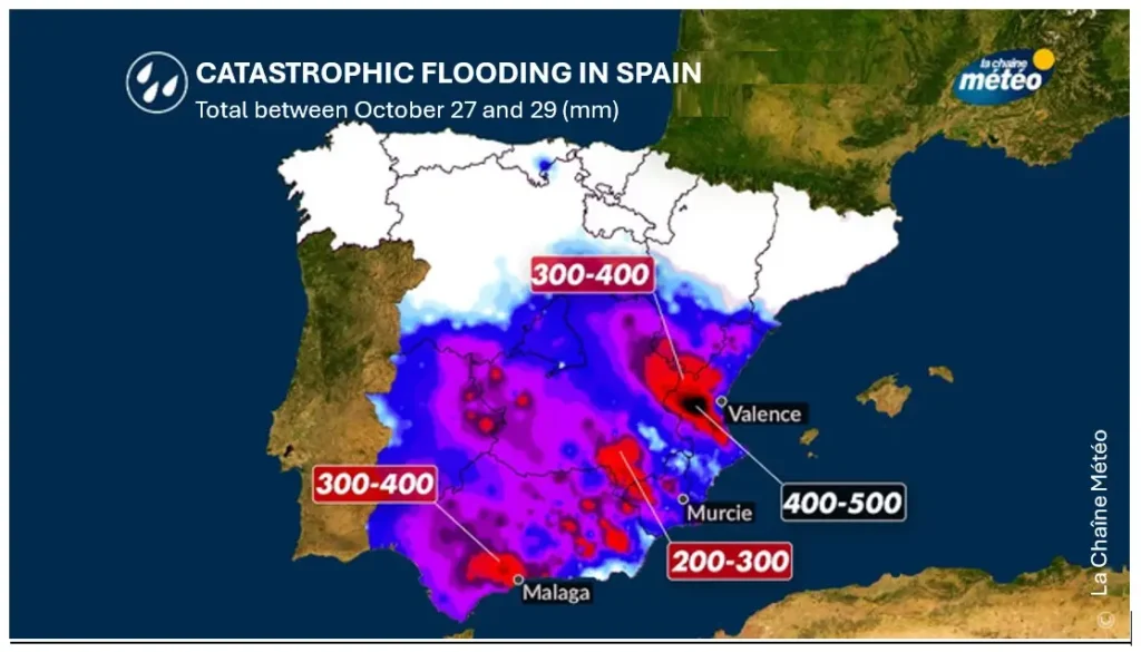
The bulk of the episode in Spain began. The cold drop, located between Morocco and Andalusia, generated powerful thunderstorms over eastern Spain. Modeling predicted up to 400 mm of rain in the region and nearly 500 mm fell. For example, 491 mm was recorded at Chiva (Valencia province). Cumulative totals are remarkable over a vast area of the country (Figure 7). Official data from the Turís weather station (Valencia Region) is historical.
The maximum rainfall recorded in one hour was 184.6 L/m2, which is the absolute record maximum in Spain (previous record: 159 L/m2 in Viaros on 10/19/2018).
OCTOBER
FOCUS ON THE THUNDERSTORM OF OCTOBER 29
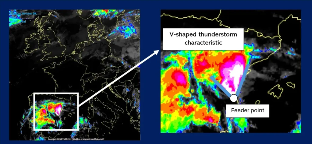
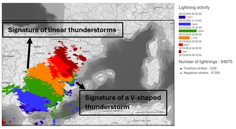
An impressive stationary thunderstorm then stalled for several hours in and around Valencia, dumping huge quantities of rain over the region. A V-shaped thunderstorm with a fixed feeder point toward Valencia (Figure 8) was detected by satellites. The systems also produced impressive electrical activity.
A V-shaped thunderstorm is a particularly devastating system because it is stationary, regenerating itself at the same point (feeder point) and dumping precipitation in the same areas, sometimes for several hours.
4 NOVEMBER
The cold drop gradually subsided (pressures rose and the dynamic weakened), but this did not prevent red alerts from being issued for Spanish regions bordering the Mediterranean. On Sunday, November 3, waves of storms pounded the same regions, already hard hit and devastated. They were less powerful than its predecessor, but the soil was saturated with water, which made drainage more difficult.
Over all the episodes, METEORAGE sensors detected:
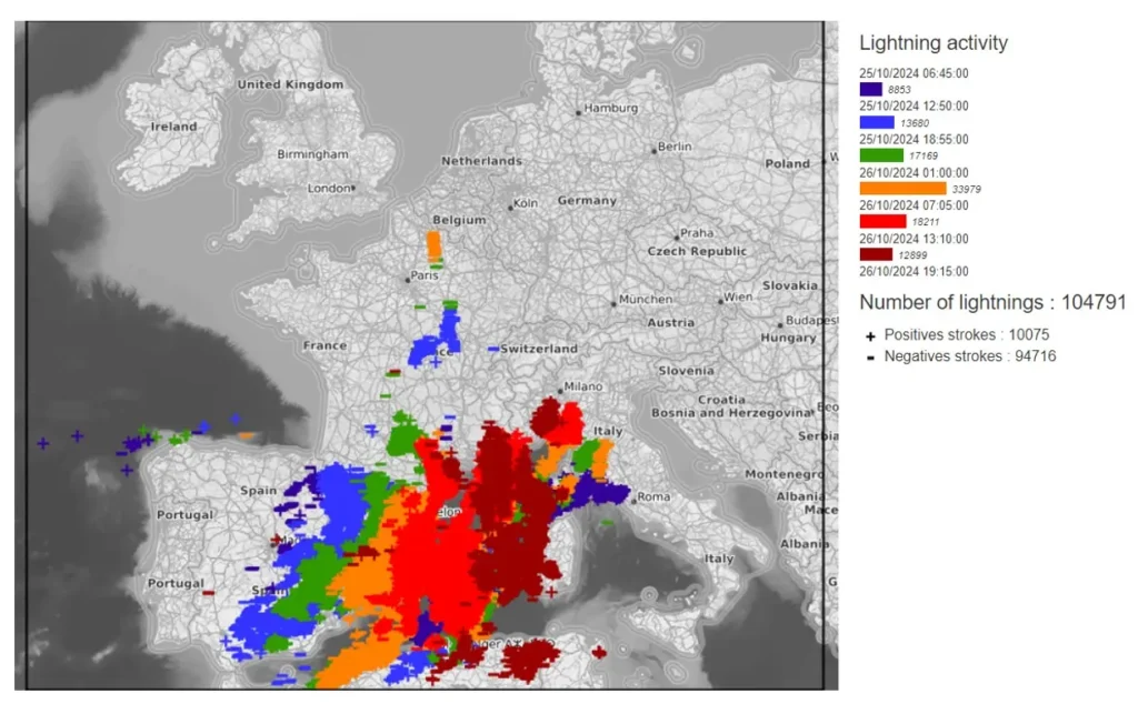
The first pre-frontal thunderstorms that swept across southern Europe from west to east were quite electric (Figure 9). More than 100,000 strikes were detected.
Most electrical activity occurred during the severe storm over southern and eastern Spain.
More than 80,000 CG flashes were detected (Figure 10) in this area in less than 24 hours. The propagation of the squall line can be seen clearly from the west to the east of the country.
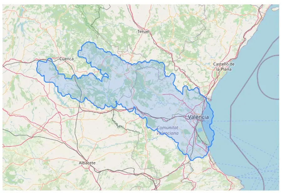
To give an idea of the size of the most intense storm cell that occurred between October 29 at 12:55 UTC and October 30 at 21:50 UTC around Valencia in Spain.
On the right (Figure 11) is the cell’s total footprint over its lifetime, i.e. just under 9 consecutive hours:
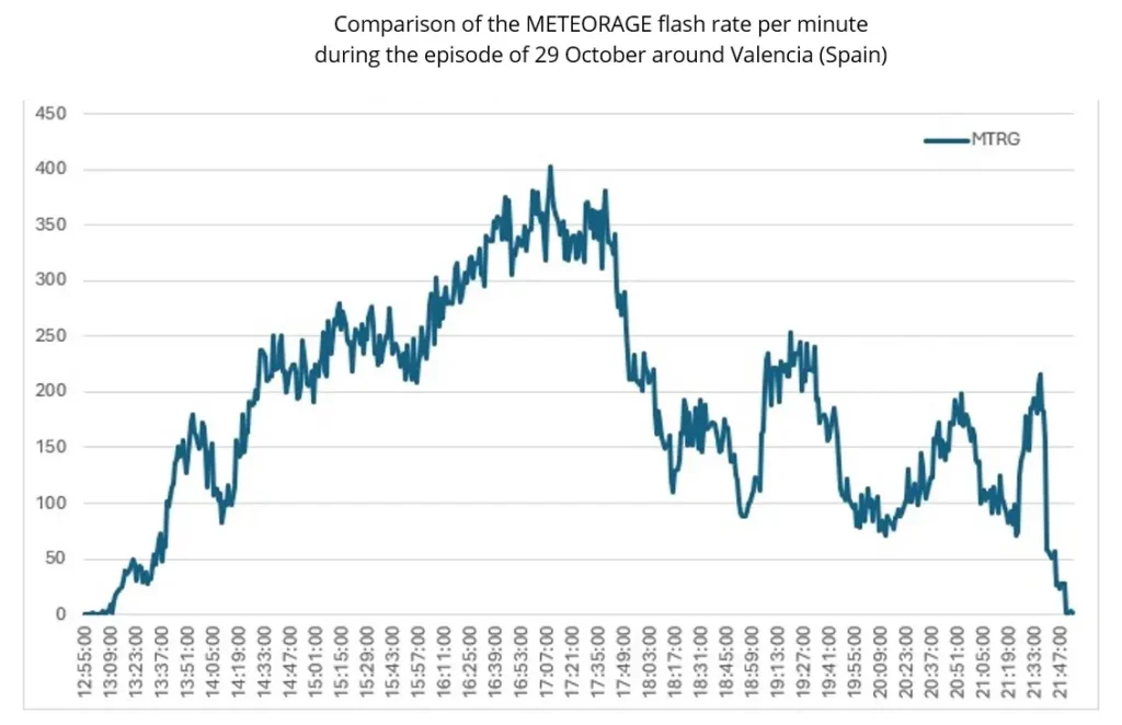
In terms of flashes per minute rate, extremely high values were recorded. A Lightning Jump was even detected at around 1:10 pm (Figure 12).
A Lightning Jump is a rapid increase in the frequency of lightning flashes (or flash rate).
This phenomenon generally precedes violent weather phenomena such as tornadoes, hail, downbursts, etc. by a few minutes.
This episode, which can be described as a major one in the Spanish region, was caused by atmospheric dynamics that were, in the end, fairly typical for this season. In fact, cold drops occur frequently on the Iberian Peninsula and waves of thunderstorms regularly sweep over countries bordering the Mediterranean in autumn.
So why was this episode so exceptional?
1.
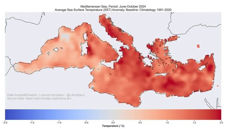
The waters in the Mediterranean were still particularly warm, with positive sea surface temperature anomalies (figure 13), the waters still reached a surface temperature of 21°C off Valencia. This water served as fuel for the development of thunderstorms.
2.
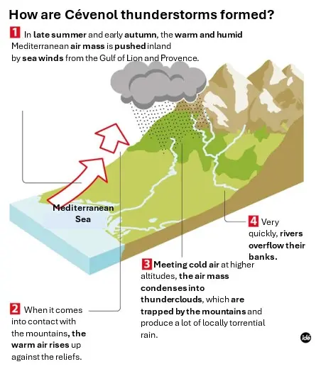
Valencia is surrounded by mountains. The warm, moist air that rises is thus trapped and forced to climb to higher altitudes, where it meets the very cold air. This powerful thermal shock leads to intense convection.
3.
A warmer atmosphere results in more humidity in the atmosphere. According to the laws of thermodynamics, for every degree Celsius that the atmospheric temperature increases, water vapour increases by 7%. More heat leads to more evaporation and therefore a higher water content in the atmosphere. This high precipitable water content is potentially dangerous during a thunderstorm, as more water will fall and increase the possibility of more intense flash floods. In the case of the thunderstorm in Spain, the precipitable water content was quite high and caused the intense precipitation observed in these regions.
4.
The soil in Spain, particularly in the Valencia region, was particularly dry after a summer with little rainfall, making it difficult for this soil to absorb water.
To conclude on these aggravating factors, the configuration of the thunderstorm (V-shaped) with its stationary character obviously did not help and explains the impressive quantities of water that fell on these regions.
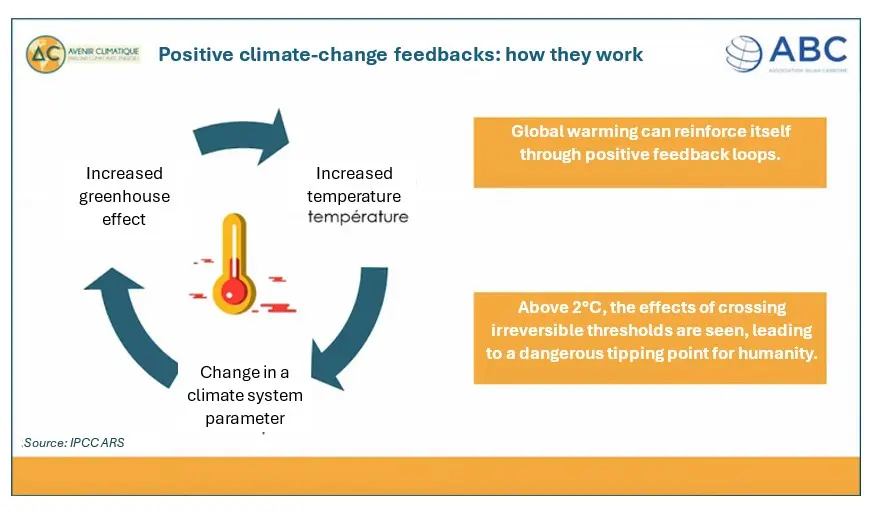
All these contributions are indirectly or directly due to climate change, which aggravates these phenomena via positive climate-change feedbacks (Figure 14). An increase in global temperature leads to one or more changes to a parameter of the climate system, with sometimes devastating consequences.
